In order to achieve successful design and implementation of a new greenway, or successful updates to an existing greenway, it is critical that the design and construction teams understand the existing conditions of the site.
The thorough understanding of the site will inform the design process and ensure that the design is built in a way that is consistent and complimentary to its location. A pre-design list has been compiled by GRG project management staff and the list below should be used throughout the design process.
 STREAMS/ RIVERS
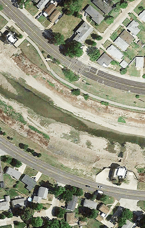
Streams and rivers are integral components to the user experience and their preservation is a critical element of the District’s environmental mission. Streams and rivers often form the backbone of the greenway system, and both visual and physical access are highly desirable for users. The dynamic nature of these moving systems, however, requires a special level of care to ensure a successful implementation over the long-term. Careful study and evaluation early in the design process is the best way to prevent long-term problems and trail failures.
- Historical analysis of a stream: Review of aerial photography or mapping to understand the historical changes of a stream or river corridor can greatly inform the placement of a greenway facility. In particular, stretches of bank or bends in the corridors that show signs of significant erosion or change (often due to new development in the watershed) should be identified. Also, stream corridors that have been highly channelized need to be evaluated, as channelized streams have significant rates of scour and a tendency toward meandering. Conditions of high variability or likelihood of failure should be avoided. If not possible, stream stabilization techniques must be used.
- In addition to stream bank stabilization, in-channel improvements should also be considered where feasible to minimize and control the erosive forces of the stream or river at proposed greenway improvements.
- Stream morphologist evaluation: In conditions where a stream or river are highly degraded or pose a significant threat to a successful trail implementation, a stream specialist should be consulted to determine the best means for establishment of a healthy corridor.
- Floodplain analysis: Floodplains and floodways should be identified and documented at the outset of a greenway project to ensure that adequate design considerations are made and that any special permitting required is initiated early in the design process to avoid significant project delays. Mapping will also help to determine where additional safety measures, including warning signage, may be required.
- Wetland mapping/ wetland delineation: Wetland areas should be documented in a project area and avoided if at all possible, unless there is a desire to make an amenity of such a natural feature. If a wetland is within the limits of disturbance, a wetland delineation will need to be performed. This will then guide the design for this area.
- Potential developments that might impact stream morphologies within the design area need to be studied and taken into design consideration.
- Stream improvements should be analyzed for a variety of return intervals up to 100-year. Additional analysis of smaller storms such as 2-year, 5-year, 10-year & 25-year may be beneficial to minimize frequency of trail inaccessibility and maintenance needs.
- The Metropolitan St. Louis Sewer District and the United States Army Corps of Engineers guidelines and regulations should be followed.
UTILITY COORDINATION
- Prior to start of construction, the designer shall contact all local utilities to identify potential constraints and necessary approvals associated with the project.
- This is also a time to discuss maintenance needs that may require maintenance vehicle access on greenway trails.
SOILS/ GEOLOGY
Soils are critical to a healthy environment and critical to the success of built infrastructure such as trail pavements and structures.
- United States Department of Agriculture/Natural Resources Conservation Service soils maps are generally available for areas that may be under consideration in a given greenway corridor. Though this data will not be particularly detailed, it will provide a starting point, indicating where soils may exist as a challenge to construction or to the implementation of landscape plantings. In particular, soils need to be assessed for their load bearing characteristics.
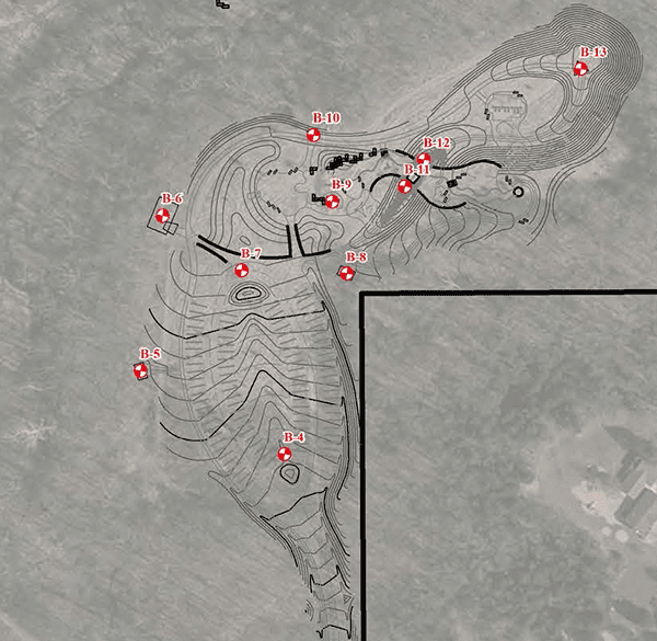
- As such, geotechnical borings are to be performed along a proposed trail alignment at an interval of every 1250’ and at critical infrastructure points, which include:
- Bridge locations (abutments and piers)
- Large stormwater structures
- Proposed lakes or bodies of water
- Large stormwater BMPs
- Any significant structures which require foundations, such as pavilions and restrooms
- Provide one boring at retaining wall locations. More borings may be needed depending length of wall
- Soil fertility testing should be conducted during this design phase of work to determine the appropriate soil amendments/ design specifications for bidding purposes. This is to better understand and budget for the costs of soil improvements prior to bidding. Soil tests should be provided in any proposed intensive planting areas, and additional spot tests should be performed on large areas planned for turf or native meadow plantings. Additional soils testing will need to be conducted following site disturbance for all planting areas. Damage to soil structure and/or fertility during construction will need to be addressed by contractor prior to planting.
 ECOSYSTEM MAPPING
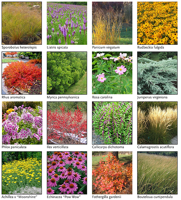
In many parts of the greenway system, existing natural areas with their unique plant communities and natural features form the preservation corridor that becomes the greenway. As the greenway system builds out, it is important to maintain consistency with and preserve these different natural areas throughout the region. One of the best ways to achieve this is through the use of plant palettes that are native and endemic to that particular greenway corridor.
- Ecosystem mapping: by mapping the existing tree and plant communities endemic to the trail corridor areas, the designer can understand the unique character of the site. This does not need to be an exhaustive analysis, but particular focus should be placed upon dominant canopy, mid-story and understory plants. Where no native plant material remains, a quick study of potential vegetation will suffice.
- This understanding of the existing vegetation will allow the designer to propose an appropriate plant palette based on restoration mentality, where the greenway trail can be seen as an improvement to the overall environment. This does not preclude plant cultivars or improved species; their usage should be limited to more highly manicured areas away from natural areas.
- Invasives targeting: this ecosystem study will also help to target areas with the greatest pressure from invasive plant species in the corridor. These areas should be considered for mitigation as part of the project.
 TREES
TREES
In addition to general mapping of tree types located within a greenway corridor, it is critical to map significant trees to remain in place within or near the trail corridor.
- Tree evaluation/ survey along alignment: ideally significant trees can be surveyed during the dormant season (Fall/ Winter) through GPS tagging. This way, the design can take these trees into account and limit the number of difficult decisions needed to be made in the field during construction. This should be done in highly wooded areas only after a conceptual design layout or alignment of the trail has been selected.
- Significant specimen trees near the trail alignment that are to remain should be evaluated by an ISA certified arborist who can suggest the most appropriate preservation techniques, during design phase and prior to construction.
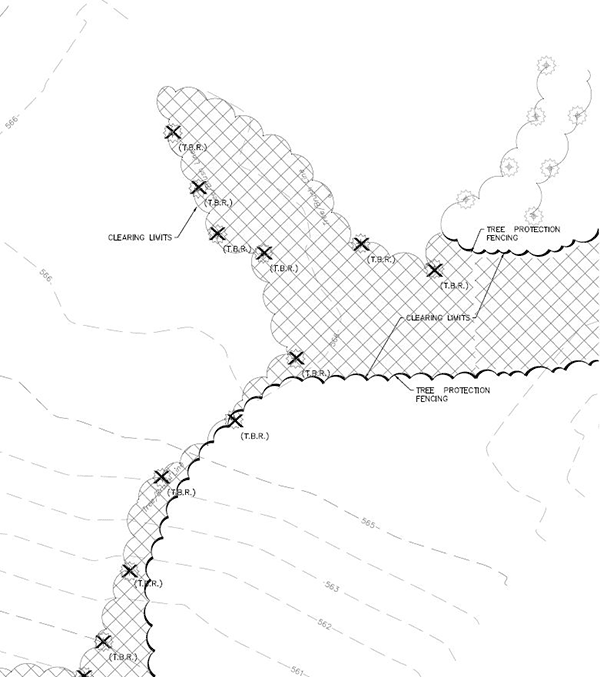
- A clear limit of disturbance should be indicated on all drawings. In areas with existing trees, limit of disturbance should reflect a maximum width of acceptable tree clearing. Trail layout should also allow a tolerance of one trail width to either side of the centerline to avoid significant trees wherever possible and allow for field adjustments. This should be clearly indicated on drawings and reflected in specifications.
- The layout of the trail and structures should take into account the critical root zone of all trees to remain in place and protected adjacent to the trail. Greenway facilities, grading and other disturbance should avoid the critical root zone. When designing, if trail or facility passes through more than one-third of the Critical Root Zone radius, the design should be adjusted, or the tree should be considered for removal so it does not become a hazard.
- A clear tree protection plan should be included in construction documents and coordinated with the selected contractor. All existing trees to remain within the limits of disturbance should be protected during construction.
- The centerline of the proposed trail should be laid out on site prior to construction. This layout should help to identify significant trees at risk, and the designers should adjust the design accordingly when feasible. For layout/ staking of route prior to tree removal:
- Remove trees and vegetation 3” or smaller
- No heavy equipment should be used at this point
- Landscape architect/ engineer to review layout prior to removal of any trees larger than 3”. Certified arborist may need to be on site for review.
- Layout to be adjusted as needed to avoid large trees within the typical float. Typical float should allows for a tolerance equal to the width of the trail on either side of centerline for adjustments.
TRAFFIC STUDY
Traffic studies are required anywhere the interface between the greenway and surrounding roadways could cause changes to lane counts or to the facility. This includes any potential impacts on the flow of vehicular traffic or where signalization is being evaluated for trail safety and lane width. The design/ engineering team should coordinate with the local road jurisdiction to determine the need for a traffic study. The traffic study should be performed early in the design process to be able to determine the best design configurations for a safe and well functioning trail.
- May be needed, particularly where interfacing with arterial roadways.
- Results of the traffic study could indicate need for signalization.
- Can allow for the evaluation of critical sight lines, stop locations, turning movements and more.
- Determine the type of crossing or additional safety features that might be required.
- Can also be used to determine the best location for roadway entrances elements such as trailheads, and can be helpful in determining the best location for trailheads and parking.