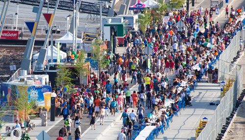
April 14, 2024 Community Celebration attracted people from across the region to see new park and visit historic bridge!
TEST TEST TEST
Tag: Mississippi Greenway – Chouteau Riverfront
Community Celebrates Katherine Ward Burg Garden April 23, 2023
Great Rivers Greenway and project partners invite you to celebrate improvements coming to the Mississippi Greenway at the Old Chain of Rocks Bridge!
Spotlight on the Mississippi Greenway
What is the Mississippi Greenway?
 The master plan for the Mississippi Greenway stretches 32 miles from the Missouri River at Pelican Island Natural Area to the Meramec Greenway near Bee Tree Park in south St. Louis County. When complete, it will connect with the Missouri Greenway, Maline Greenway, the Trestle, the Arch grounds, Gateway Mall and River des Peres and Meramec Greenways south of downtown St. Louis.
Projects within the greenway include Jones-Confluence Point State Park in St. Charles County, the Old Chain of Rocks Bridge and Riverfront Trail in the City of St. Louis, the McKinley Bridge Bikeway and Branch Street Trestle and the Trestle in the City of St. Louis.
Current Status
North-Downtown St. Louis Riverfront to Old Chain of Rocks Bridge
The 12.5 mile Mississippi Greenway: Chouteau Riverfront to Old Chain of Rocks Bridge (Riverfront Trail) winds through both sides of the flood wall that protects the City of St. Louis and offers views of the working riverfront that even most native St. Louisans have never seen before. A 1.5 mile extension from Biddle to Chouteau opened in June 2016 and now connects to the new circulation pathways on the Gateway Arch grounds.
South- Cliff Cave County Park and Jefferson Barracks to River des Peres
Currently, there are two completed greenways south of downtown St. Louis along the Mississippi Greenway–Cliff Cave County Park and Jefferson Barracks to River City Casino.
Mississippi Greenway: Jefferson Barracks to River City Casino extends 1.6 miles from the trailhead in Jefferson Barracks Park to the northern edge of the River City Casino Property along the River des Peres. Visitors to Jefferson Barracks Park in St. Louis County can use this greenway to get an up close view of the Mississippi River, and will soon be able to walk or ride all the way to Carondelet Park or the Lansdowne-Shrewsbury MetroLink Station via the River des Peres Greenway.
Mississippi Greenway: Cliff Cave County Park is a 4.7 mile loop (paved) nestled in a unique park that gets its name from the cave tucked in the bluffs of south St. Louis County. The park offers hiking, mountain biking, and equestrian trails as well as picnic areas and shelters. Construction on a new overlook, two bridges and a paved, ADA accessible greenway that will connect the upper and lower sections of the park along with a neighborhood spur out to Telegraph Road is underway. Click here to see videos of the bridge installations. (Fun fact: the new bridge over Cliff Cave Road is largest single span pedestrian bridge in the region!)
Exploring the Mississippi Greenway
There is so much to see along this greenway from iconic landmarks to industrial operations, to sweeping views of the Mississippi River!
Old Chain of Rocks Bridge:
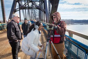 For more than three decades this bridge was a landmark for travelers along Route 66. It is now open daily for people to walk or ride bikes to connect to Illinois or simply enjoy views of the Mississippi River! The bridge has appeared in movies such as “Escape from New York” in 1980 and most recently for “The Empty Man” slated to be released sometime in 2018. In February 2018, the bridge will be closed to all visitors for approximately one month to complete some necessary repairs to the bridge deck.
Mark your calendars to join us January 13 and 14, 2018 for Eagle Days at the Old Chain of Rocks Bridge—a two day festival celebrating our nation’s emblem bird.
NOTE: There is no parking on the Missouri side of the bridge, but you can park on the Illinois side –Click here for directions. Of course, you can also ride your bike from downtown St. Louis near the Arch grounds!
Cliff Cave Park:
While construction is underway in the upper section of the park, bring your bike or enjoy a walk on the Mississippi Trail. This 4.6-mile paved, loop asphalt trail circles the floodplain bottomland and offers beautiful views of the river and fall colors on the bluffs. Plan your visit here.
Projects and Partnerships along the Mississippi Greenway
Greenway Guides
 For the past three years, Great Rivers Greenway has partnered with the Urban League of St. Louis for the Greenway Guide Program. After completing training with the Urban League, Guides work together with staff, other support teams and partners at the City of St. Louis to monitor and patrol this greenway. Guides also operate the Mary Meachum Visitor’s Center—Friday through Sunday—offering support such as bicycle repair, directions and first aid. Not only does the partnership provide excellent job training and employment for our community through the Save Our Sons program, it also enhances the experience for people using the Mississippi Greenway from the Old Chain of Rocks Bridge to Leonor K. Sullivan Blvd at Chouteau. Since its inception in 2015, 18 individuals have leveraged their experience as a Greenway Guide into full-time jobs.
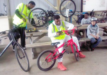
On-the-Job Horticulture Training with St. Patrick Center
Great Rivers Greenway has teamed up with the St. Patrick Center to provide hands-on maintenance, landscape and horticulture training along the Mississippi Greenway. St. Patrick Center clients work side-by-side with Great Rivers Greenway staff and other partners to maintain three pollinator gardens at the McKinley Bridge Bikeway, Mary Meachum Center and Old Chain of Rocks Bridge. They also assist as needed with weeding, mulching, pruning, and invasive species removal.
Not only does this provide valuable on-the-job landscaping and trade skills for the St. Patrick Center clients, it also helps restore habitat, better maintain the greenway, and enhance the visitor experience for everyone. Watch a video about the program here.
Pollinator Partnership with St. Louis University
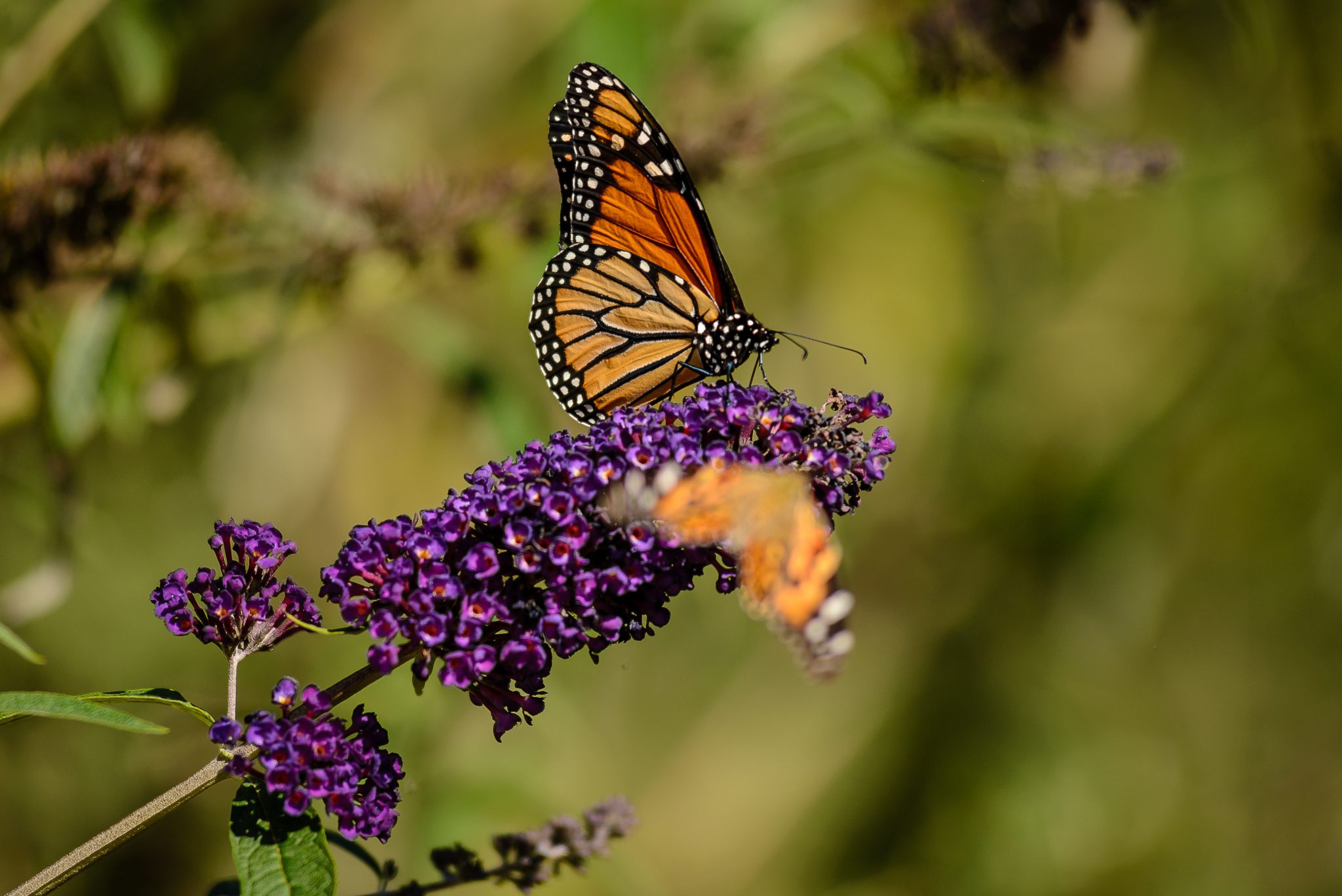 Great Rivers Greenway has partnered with St. Louis University to host two internships on pollinator diversity in urban environments. These positions support research efforts currently underway by St. Louis University Associate Professor of Biology Dr. Gerardo Camillo. To date, he has documented 169 species of bees in St. Louis –the highest bee diversity of any city in North America. The science-based data collected will be used to guide the District’s efforts of creating pollinator habitat to increase biodiversity. You can watch the video of an interview with Dr. Camillo and the interns here.
Greenway Alert: Temporary Closures
There are some temporary greenway closures that will reduce or limit your access to a few of the greenways in the coming months. Here is what you need to know before you go:
The Mississippi Greenway south of the Merchant’s Bridge-between Bremen Ave and Ferry Street
 One of the barge conveyors that crosses over the Mississippi Greenway south of the Merchant’s Bridge will be replaced in June. The greenway will be completely closed on Tuesday June 6th to accommodate the removal of the old structure and Wednesday June 14th for the placement of the new one. Once the new conveyor has been put in place, there will still be some ongoing overhead work. When the work is taking place directly over the greenway, the construction firm will place barriers at Bremen Avenue to the south and Ferry Street to the north to shut down the greenway. The construction firm will have people in yellow and orange safety vests stationed on the greenway to intermittently stop bicycle and pedestrian traffic as needed for safety reasons. They can communicate and/or escort people through, but only if it is safe to do so. If not, people will have to turn around and will be unable to use the greenway in this area. We will post any relevant updates or alerts about this work on our Facebook Page and Twitter. Please note this work is weather dependent and the dates may change accordingly.
Missouri Greenway Monarch Chesterfield Levee
The Missouri Greenway Monarch Chesterfield Levee is closed at Long Road through March 2018 to accommodate levee pump station work by the United States Army Corps of Engineers. You can still use the greenway on either side of this closure, but there is no temporary re-route around the construction. Click here for more details and a map.
Centennial Greenway on Washington University Campus and Forest Park Parkway Bridge
The segment of the Centennial Greenway that travels through the Washington University campus is closed through August 2017 to accommodate construction on the Danforth campus. Washington University has established a detour that will take you around the campus via the sidewalk on Forsyth, a new dedicated bike and pedestrian walkway on Big Bend Blvd., and through the Ames Place neighborhood to connect with the existing greenway along Melville Ave. Click here for a detailed map of the detour.
In addition, the bicycle and pedestrian bridge crossing over Forest Park Parkway is under construction making the bridge temporarily inaccessible. Pedestrians and cyclists should follow the temporary detour outlined above (Click here for a detailed map of the detour) or use Skinker Blvd. to connect to Forest Park, the Delmar Loop or the Washington University campus. These detours will add extra time to your walk or bike ride. Please be sure to plan your trip accordingly!
Mississippi Greenway from Eads Bridge to Arch grand staircase will be closed for Brewers Guild Heritage Festival June 11, 2016
 The Mississippi Greenway will be completely closed from the Eads Bridge to the Arch grand staircase all day Saturday June 11, 2016 for the St. Louis Brewers Guild Heritage Festival.

This is a ticketed event, and only people holding tickets will be able to enter the area.
Here is what you need to know about visiting the Arch grounds, Riverfront, and Laclede’s Landing on June 11, 2016:
Access to the Arch grounds and southern portion of the greenway:
The greenway will be open for everyone from the Arch grand staircase south to Chouteau Ave. You can access the Arch grounds via Walnut Street, then walk down the grand staircase to the southern portion of the greenway along the riverfront. You can also enter via Chouteau Avenue, but parking will be limited on the levee due to recent flooding.
Access via Metrolink:
People with tickets to the Brewer’s Guild Heritage Festival can use the Laclede’s Landing MetroLink Station to access the event. People who want to visit Laclede’s Landing can also use this station, but will be unable to connect with the greenway south of the Eads Bridge.
People who want to visit the Arch Grounds and Riverfront should exit at the 8th and Pine Street MetroLink Station and enter via Walnut street as described above.
Accessibility:
People with limited mobility or who use a wheelchair, can only access the Riverfront via Chouteau Ave.
Parking:
There will be some levee parking available this weekend, but it may be limited due to recent flooding. The entrance to the parking lot is at the intersection of South Poplar Street and Leonor K. Sullivan Blvd. People with tickets to the Brewers Guild Heritage Festival can park on Laclede’s Landing. Others should park in any of the preferred parking lots in downtown St. Louis. Click here to see a list of downtown parking lots.
Access to the Riverboats from the south will not be affected by the Heritage Festival.
The greenway will reopen on Sunday June 12, 2016.
Click here for more information about the Brewers Heritage Festival.
YOUR new Riverfront is open!
Come down and see it for yourself!
 The renovation of the 1.5-mile stretch of riverfront is ready for you to explore and enjoy. The project includes the recently rebuilt Leonor K. Sullivan Boulevard and extension of the Mississippi Greenway from the Biddle Street Trailhead south to Chouteau Avenue, with protected walking and biking paths. The entire riverfront has been elevated an average of almost two feet to limit flooding, returning more days of the year back to you for walking, riding bikes, sightseeing and special events.
While the historic elements were preserved, such as the cobblestones lining the levee; new amenities such as benches, bike racks, lights, power outlets and a street-level stage make the space more inviting for events and programs. The lineup for this summer and fall includes bike rides, walk/run events, the St. Louis Brewers Guild Heritage Festival, a free concert series with The Sheldon, swap meets and more. Click here to see the upcoming events.
 Click here for a downloadable map that shows how to get around downtown on foot.
What you need to know before you go:
Leonor K. Sullivan is now open to two way traffic. The street will be closed for certain special events. Most of the time, the greenway and sidewalk will be open for people walking or riding a bike. Only during specific ticketed events will the entire riverfront be closed for a special event, such as the St. Louis Brewer’s Guild’s Heritage Festival on June 11th.
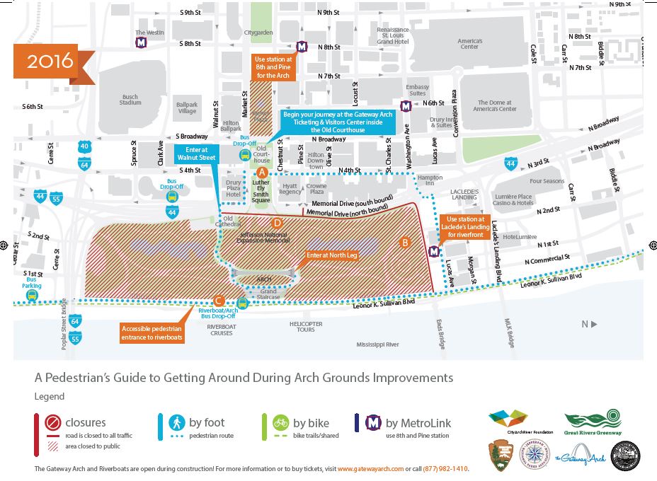
Pedestrian Access from Arch Grounds (under Construction) to Riverfront:
You can access the Arch Grounds in front of Old Cathedral at Walnut Street. Walk across the Arch grounds, then walk down the Grand Staircase to the new Riverfront. Note that during Arch construction, there is a fenced pathway that meanders to the north leg of the Arch and the grand staircase.
Automobile Access to the Riverfront, LKS Blvd:
You can drive via Chouteau from the South or Laclede’s Landing Blvd on the North. NOTE: Washington Avenue on the north side of the Arch grounds is permanently closed. It is now part of the Arch grounds, referred to as the north gateway.
Bicycle Access:
Until the East and West sloping pathways on the Arch grounds are complete, the best way to access the greenway on bike is from Chouteau Avenue on the south, Laclede’s Landing and the Mississippi Greenway (Riverfront Trail) from the north. There are bike racks available on Leonor K. Sullivan Blvd.
Where to Park?
Parking on the Riverfront:
The entrance to the levee parking lot is at the intersection of South Poplar Street and Leonor K. Sullivan. (Note that the Levee Parking Lot may not be available if the Mississippi is at flood stage. There is no street parking on Leonor K. Sullivan Blvd. During certain events, there will be parking on the north end of the levee (again, flood stage dependent).
Parking in downtown St. Louis:
You can park in Laclede’s Landing or in downtown St. Louis. Click here for a list of parking garages in downtown St. Louis.
Access to Riverboats:
Riverboat Cruises will always be accessible, even during special events. The entrance to the levee parking lot (directions above) is at intersection of South Poplar Street and LKS.
Access via the Downtown Trolley:
Exit the Downtown Trolley at 4th Street by the old Courthouse, then walk to the Arch Grounds.
Access via Metrolink:
For Riverfront, exit at Laclede’s Landing MetroLink Station
For Old Courthouse, to buy Arch Tickets, use 8th and Pine MetroLink Station
Getting Around downtown during CityArchRiver Construction:
Click here for maps and more information about getting around downtown during CityArchRiver Construction.
Visiting the Gateway Arch:
Yes! Our iconic Gateway Arch is till open during CityArchRiver Construction. Click here for more information about buying tickets, where to go, hours, etc.
Accessibility
Until the new sloping pathways on the Arch Grounds are complete, people using wheelchairs or who have limited mobility should park on Laclede’s Landing and then head towards the river where you can access the new greenway.
Greenway Guides on Riverfront Trail In Partnership With Urban League

Great Rivers Greenway is thrilled to be partnering with the Urban League to implement a greenway guide program on the North Riverfront Trail. Not only will this partnership provide excellent job training and employment for our community with the Save Our Sons program, but also enhances the experience for those using our network of greenways to be active, get around town or just enjoy being outside.
This pilot project will take place on the portion of the Mississippi River Greenway that stretches from the Old Chain of Rocks Bridge to the north to the Biddle Street trailhead on the south. Later this fall, we’ll extend the greenway south to Chouteau, when our project on Leonor K. Sullivan Boulevard in front of the Gateway Arch grounds is completed.
Guides will work together with our other support teams and our partners at the City of St. Louis to monitor and maintain this greenway, including trail maintenance and conservation projects to enhance the area. Guides will also operate the Mary Meachum Visitor’s Center, offering support like bicycle repair, way finding directions and first aid.
We’re excited to work with the Urban League to develop qualified ambassadors to greet and support visitors exploring the greenway. For us, having a community presence on the riverfront is key. This is an opportunity to connect residents of north city to this recreational resource and cultural sites like the Mary Meachum Freedom Crossing, where we’ll celebrate the 150th anniversary of the end of slavery May 9th.
We are building, promoting and sustaining this network of greenways to make the St. Louis region an even better place to live. This project is just one way we’re engaging residents of the region to connect with their investment, this network of greenways, and each other. We hope you’ll visit and experience the benefits of this partnership first hand!
