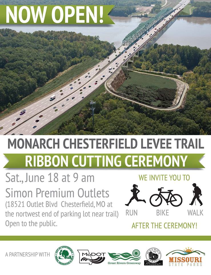
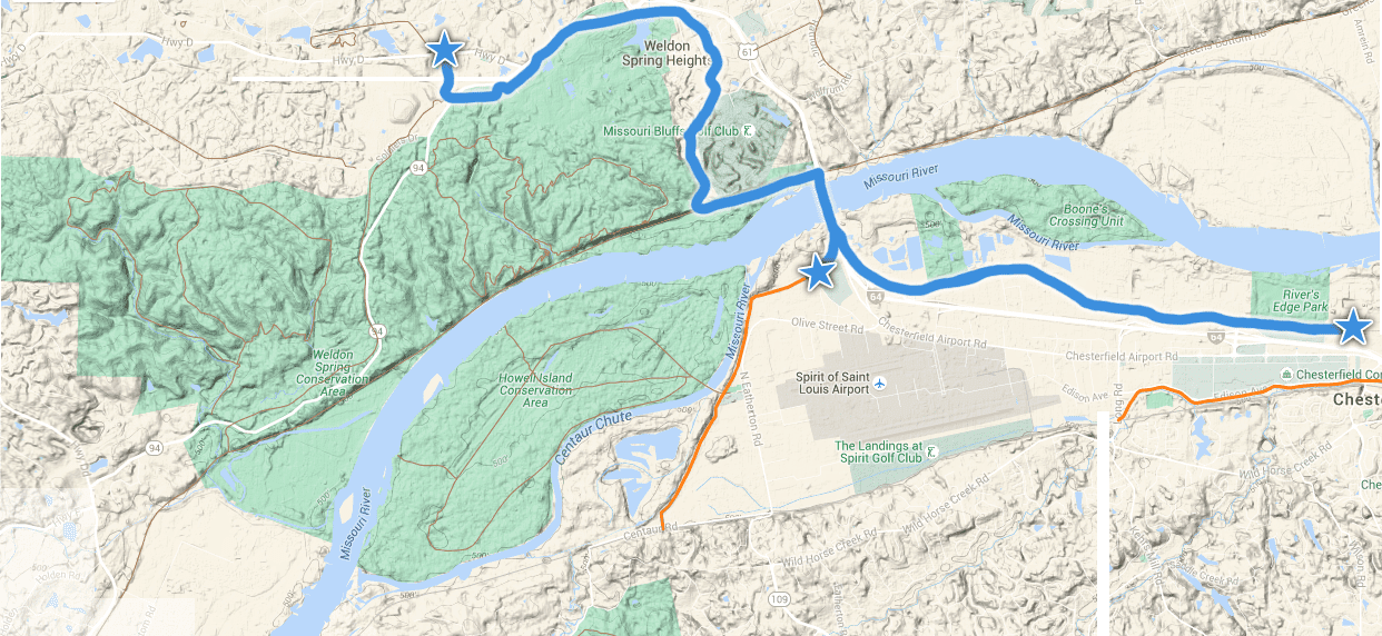
This greenway getaway is built around the walking and biking path on the Boone Bridge over the Missouri River. It offers stunning river views and connects two counties (St. Louis, St. Charles) and two greenways (Busch and Missouri Greenway: Monarch Chesterfield Levee) via the KATY Trail.
Whether you are just getting back on your bicycle, are a marathon runner, or simply looking for a new place to walk—this “Greenway Getaway” has something for everyone. Here are a few options depending on what you want to do!
5 MILE ROUTE

Starting at Busch Greenway Duckett Creek Trailhead in Missouri Research Park
This is a perfect walk, run or easy bike ride for people of all ages. It offers plenty of shade, great river views and there are no steep hills! Park at the Busch Greenway Duckett Creek Trailhead in the Missouri Research Park and walk .75 miles on the paved greenway down the bluff to the KATY Trail. Take a left, (east) and walk one mile to the new “cloverleaf” that takes you up to the pedestrian path across the Boone Bridge. At first glance, it looks a little steep, but the incline is very gradual. There are a couple of bump outs on the bridge where you can stop and enjoy the views of the Missouri River. Keep walking or riding across the bridge to the Missouri Greenway: Monarch Chesterfield Levee. The trip across the bridge from the cloverleaf to the Missouri Greenway is .75 miles. Stop at St. Louis Premium Outlets for a quick break. Turn around and head back across the river the same way for a total trip of 5 miles. (shorten the trip by turning around on the bridge.)
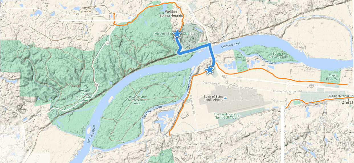

13 MILE ROUTE
From Missouri Greenway: Monarch Chesterfield Levee at St. Louis Premium Outlets
This trip offers gorgeous views of the River from atop the bridge and along the KATY Trail. St. Louis Premium Outlets welcomes you to park in the northwest corner of their parking lot near the levee. You can also use their restrooms during business hours. You will have to walk up a short gravel road to access the Missouri Greenway’s paved trail on the levee. The trip across the bridge to the KATY trail is .75 miles. Travel down the cloverleaf and take a right (west) on the KATY Trail for one mile to connect with the Busch Greenway. Once you are on the Busch Greenway, you’ll meander through a shady hardwood forest as you head up the bluff towards Missouri Research Park (.75 miles). As you travel through Weldon Spring Conservation Area, you will enjoy lake overlooks, abundant wildflowers, and the occasional deer or wild turkey. Be sure to stop and read the interpretive signage that explains the history of the area. Just past the Highway 94 underpass you will come to a rain garden in a “roundabout.” You can continue to Highway D where the paved trail ends.
The mileage breakdown for the 13 mile trip is as follows:
.75 mile (paved) on Missouri Greenway: Monarch Chesterfield Levee across bridge from St. Louis Premium Outlets to KATY Trail
1 mile on KATY Trail (unpaved) to connect with Busch Greenway
.75 mile (paved, gentle incline) to Duckett Creek Parking Lot in Missouri Research Park (drinking fountain)
4 miles (paved) from Duckett Creek Parking Lot to Highway D
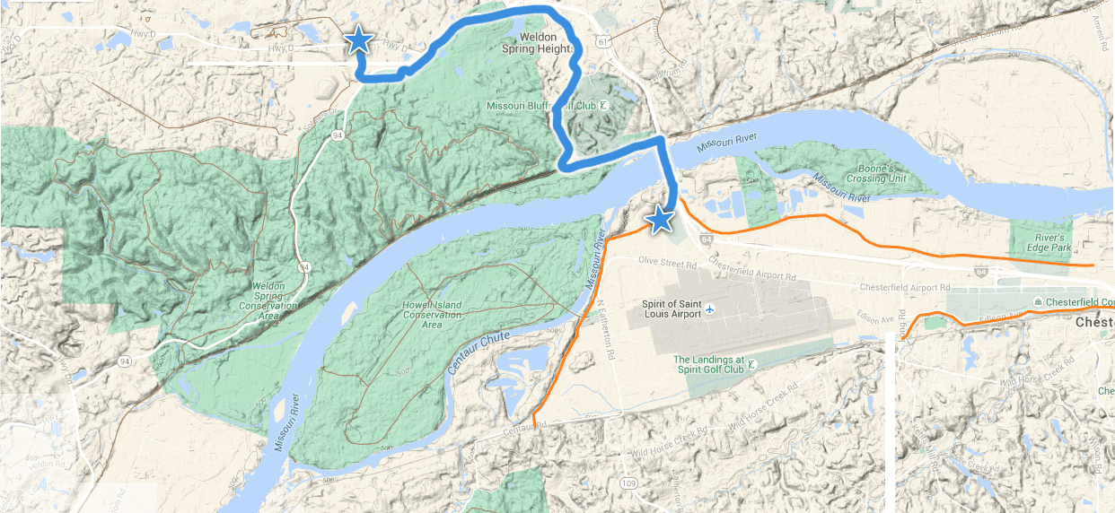
19 MILE ROUTE
You can add an additional six miles (three miles out and back) to the 13 mile route for a total of 19 miles. Stay on the paved Missouri Greenway: Monarch Chesterfield Levee and continue west, past the Premium Outlet Parking lot for three miles to where it currently ends at Centaur Road.
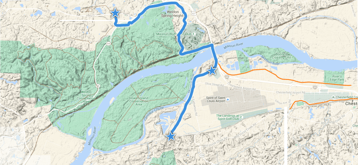
23 MILE ROUTE

Feeling ambitious? You can add another 10 miles (five miles out and back) to the 13 mile route for a total of 23 miles. Once you cross back over the Boone Bridge, take a right and go down the hill and under Highway 40 on the Missouri Greenway: Monarch Chesterfield Levee. Follow it for five miles to where it currently ends just past The District at Chesterfield (formerly Taubman Prestige Outlets). This is a flat, easy and sunny route.
OFF ROAD HALF-MARATHON ROUTE (13.1 MILES)
The Busch Greenway completes a 13.1 mile loop between the KATY and Hamburg Trails. This route is best for running or walking. You can do it on a bike, but you must have mountain bike tires as the route that follows the Hamburg trail is unpaved with a fairly rocky base. (The gravel is larger as compared to the KATY Trail.) Park at the Duckett Creek Trailhead parking lot. Run up the hill through Missouri Research Park and follow the greenway under highway 94 (4 miles). Just beyond the underpass, you will see a “roundabout” with a rain garden. Look for the sign that points to the Hamburg Trail and keep going (approx 3.75 miles) until it connects with the Katy Trail at mile marker 56.7. Go left (east) on the KATY for 4.6 miles to mile marker 52.1 and follow the paved Busch Greenway .75 miles back up the bluff to the Duckett Creek Trailhead where you began!
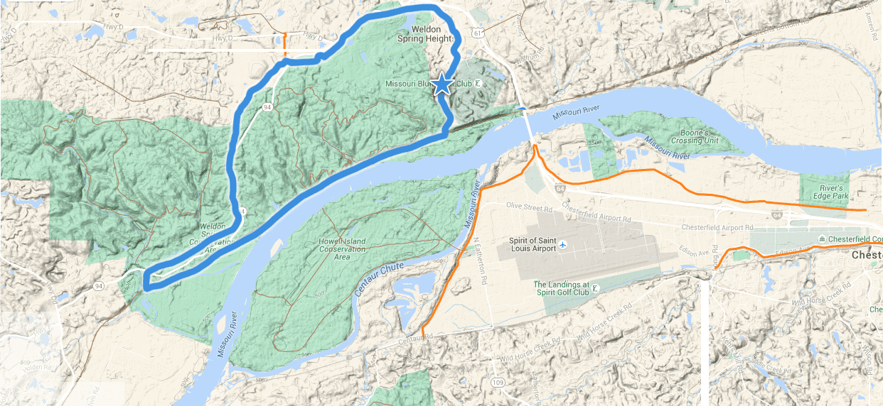

About the Busch Greenway
The Busch Greenway connects to the KATY Trail at mile marker 52.1. From there, it meanders 4.75 miles through Missouri Research Park and Weldon Spring Conservation to Busch Conservation Area at Highway D. Click here to learn more about the Busch Greenway and other sights along the way!
About the Missouri Greenway: Monarch Chesterfield Levee Trail
This greenway offers three segments which will eventually connect for a 17-mile loop. A 5.5 mile segment is now complete from Top Golf to Chesterfield Valley Athletic Complex and across the Boone Bridge. You can also follow the greenway in the other direction three miles to Centaur Road. A two mile segment has also been completed on the Monarch Levee from Long Road to Baxter Road. Click here to learn more about the Missouri Greenway: Monarch Chesterfield Levee Trail .