First identified in the 2020 Regional Plan and confirmed by 2024 North County Listening Tour, this proposed greenway project would extend the existing Sunset Greenway from Coldwater Commons Park in Florissant approximately 6 miles south to the proposed intersection of St. Vincent Greenway and Maline Greenway near Ramona Lake Park. The initial stage of the project will consider the alignment between Coldwater Park to Frostwood Park in Berkeley. The Sunset Greenway extension from Coldwater Park to Frostwood Park will be designed and developed in multiple phases.
Project Location
This future greenway project would extend the existing Sunset Greenway from Coldwater Commons Park in Florissant 6.6-miles south to St. Vincent Greenway at the North Hanley Metrolink Station.
The design team is creating their final report that will document the alignment (route) options that were studied, a summary of community engagement, and more. Thank you to our Community Advisory Committee (CAC) for their input! Keep an eye out here for the report; we will post it once it’s finalized (sign up for updates at the bottom of this page to get the latest project news).
Community Feedback: Shaping the Greenway
2024
As a recommendation from the 2024 North County Listening Tour, county residents identified a potential extension of Sunset Greenway as a high priority for Great Rivers Greenway to explore.
July 2026
Thank you to those who attended our open house in July of 2026! If you were unable to attend, you can view the presentation below.
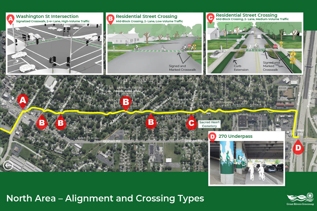
This board illustrates the proposed Sunset Greenway alignment through the northern portion of the study area, extending from Coldwater Commons Park to I-270. The alignment primarily follows the existing Ameren transmission corridor while connecting surrounding neighborhoods, parks, and destinations. The board also highlights roadway crossing treatments being considered. Proposed crossing improvements are intended to enhance safety and range from marked crosswalks on neighborhood streets to signalized crossings at Washington Street and the existing I-270 underpass.
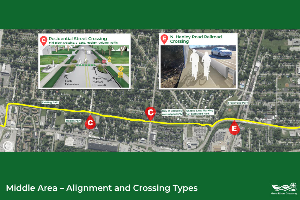
This board illustrates the proposed Sunset Greenway alignment through the middle portion of the study area, extending from I-270 to 1st Street in Berkeley. The alignment primarily follows the existing Ameren transmission corridor. The board also highlights the roadway crossing treatments being considered. Proposed crossing improvements are intended to enhance safety and include marked crosswalks on neighborhood streets, enhanced pedestrian crossings, and improvements at the North Hanley Road railroad crossing.
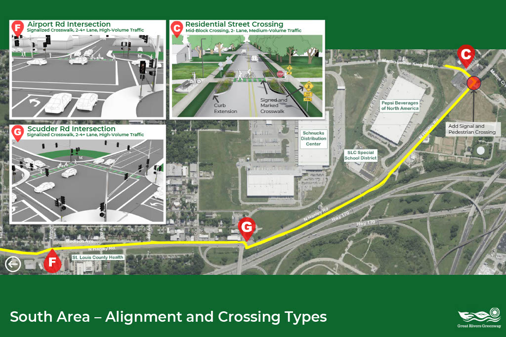
This board illustrates the proposed Sunset Greenway alignment through the southern portion of the study area, extending from 1st Street to Martin Luther King Boulevard. The alignment primarily follows the existing Ameren transmission corridor while connecting neighborhoods, parks, and future greenway destinations. The board also highlights the roadway crossing treatments being considered. Proposed crossing improvements are intended to enhance safety and include signalized crossings at Airport Road and Scudder Road, along with enhanced crossings on neighborhood streets.
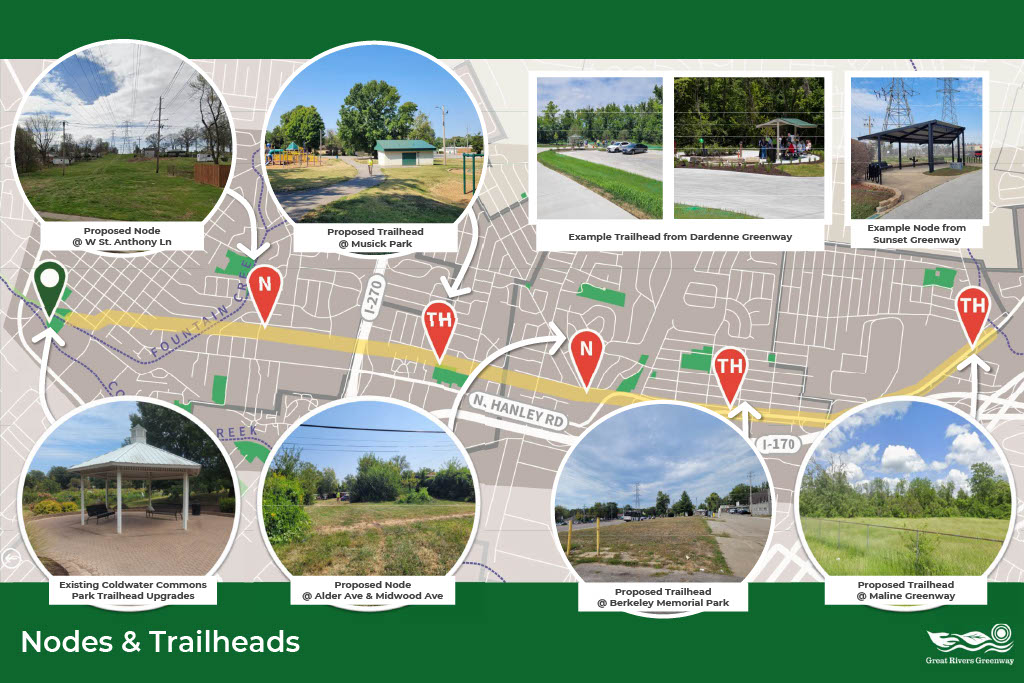
This board identifies the proposed locations for neighborhood nodes and trailheads along the Sunset Greenway corridor and illustrates how these features will provide access to the greenway through trailheads and places to stop, rest, and gather at neighborhood nodes. The board includes existing site photographs and examples from completed Great Rivers Greenway projects to illustrate the types of improvements that could be incorporated as the project moves into future design.
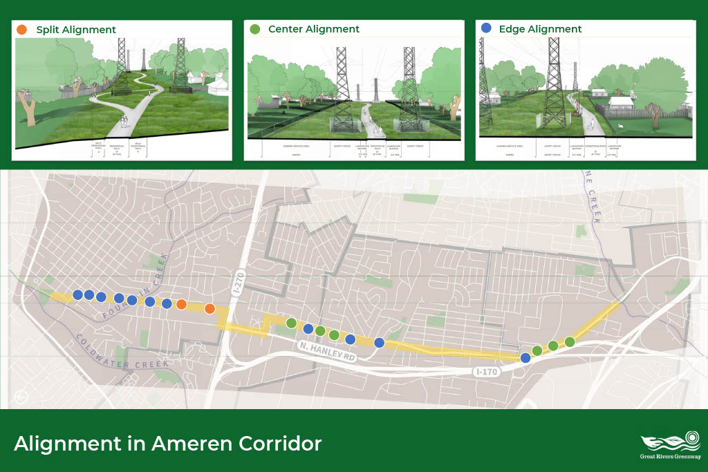
This board illustrates several proposed trail alignment strategies within the existing Ameren transmission corridor, including center, edge, and split alignments. The alignment strategy varies throughout the corridor to respond to available space, existing utility infrastructure, user experience, and long-term maintenance and operational requirements.
March 2026
Thank you to those who attended our open house in March of 2026! If you were unable to attend, you can view the presentation below.
 Contact
 Donate
 Languages
 Events

 Visit Greenways
 Future Projects
 Get Involved
 How We Work