 Contact
 Donate
 Languages
 Events

 Visit Greenways
 Future Projects
 Get Involved
 How We Work
Project Overview
The vision for Centennial Greenway is to create a regional link between St. Charles County, St. Louis County and the City of St. Louis, connecting 370 Lakeside Park, Katy Trail State Park, Creve Coeur Park and Forest Park. Currently, there is a renewed effort to advance numerous Centennial Greenway segments to achieve the grand vision, including this 2.3-mile segment between I-170 and Heman Park in University City.
An alignment for Centennial Greenway between Heman Park and Groby Road was under consideration in 2014 but Great Rivers Greenway faced physical, environmental and financial challenges in advancing the project. GRG is now interested in considering alternative alignments to complete the greenway between Heman Park and I-170.
To stay up to date on this project, subscribe to updates at the bottom of this page.
Project Location
Great Rivers Greenway is partnering with University City on an extension of Centennial Greenway between I-170 and Heman Park.
Project Partners
Current Status

Map + Concept Renderings
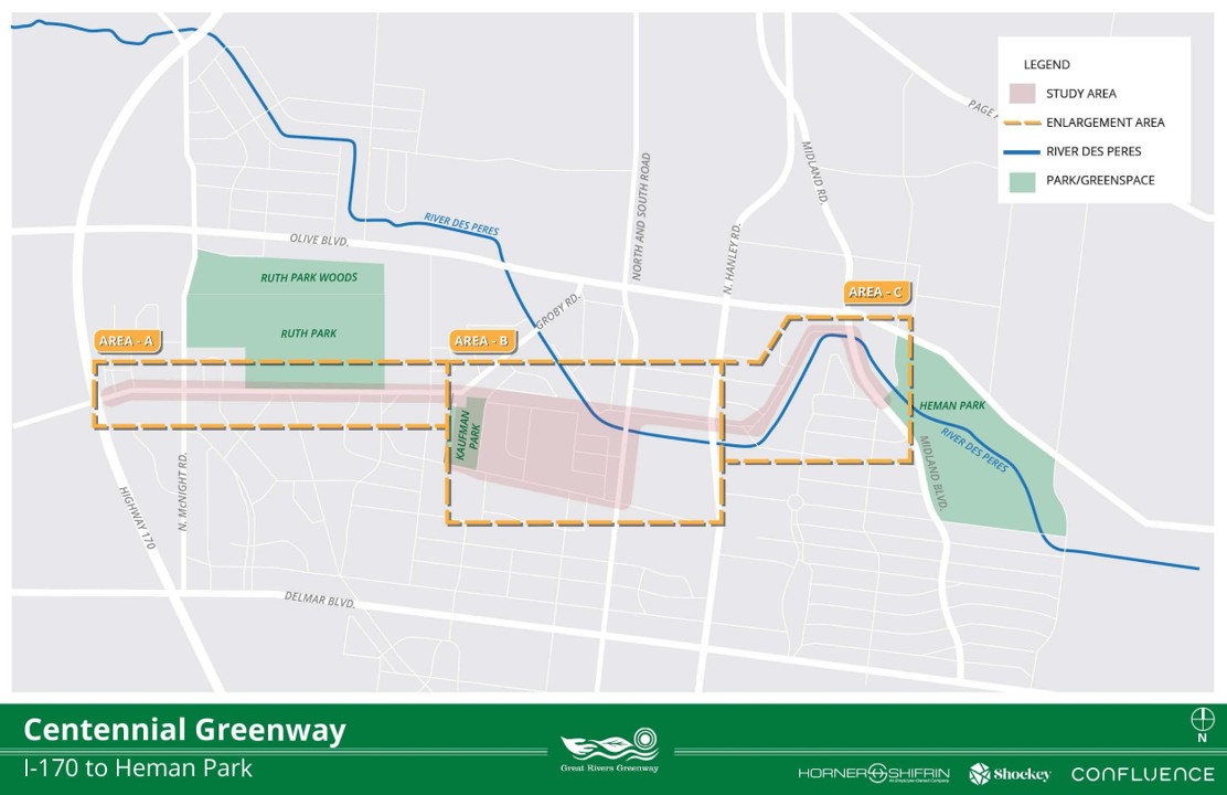
Vicinity Map: This shows the project area in reference to existing greenways, parks, and major roadways.
Floodplain map: This map shows the floodway in dark blue, 100 year floodplain in light blue and 500 year floodplain in yellow.
Project synopsis: includes photos from Open House #1, project timeline, and summary of survey comments.
Potential Alignment Map A: Summarizes the key points, and shows potential cross section, example crossing, and Area C alignment. Greenway connects to the existing Centennial Greenway at I-170 and continues on the north side of Old Bonhomme Rd. Crosses to the south at 81st Street and Gay Ave.
Potential Alignment Map B: Greenway continues along Old Bonhomme to Shaftesbury Ave. It runs past the Mona Trail and over the River Des Peres using a proposed pedestrian bridge. An alternate alignment is shown in red that would mitigate the need for a new bridge, utilizing neighborhood streets.
Potential Alignment Map C: After crossing a proposed pedestrian bridge, the greenway continues along Shaftesbury to Wilson Ave. Here there are two alignment options, the proposed alignment which meanders through the green space adjacent to Wilson and an alternative that would lie along the edge of Wilson Ave, potentially extending into the over widened street. The greenway would then connect to Midland Blvd, running along the southwest side of the street. Depending on feasibility, an alternative alignment is shown in dark red on the opposite side of the street. The greenway would then connect into existing Heman Park Trails.
Community Feedback: Shaping the Greenway
Thanks to everyone who joined us for our May 2026 Open House. We talked about preliminary planning information (project area, background info, etc.) and gathered community feedback on potential destinations, routes, priorities, and more. We also hosted an Open House on June 30, 2026, followed by an online survey. Thank you to all those who participated!
Questions? We’re Here to Help!
For questions, comments, or concerns about this project, please reach out to info@grgstl.org or call (314) 436-7009.