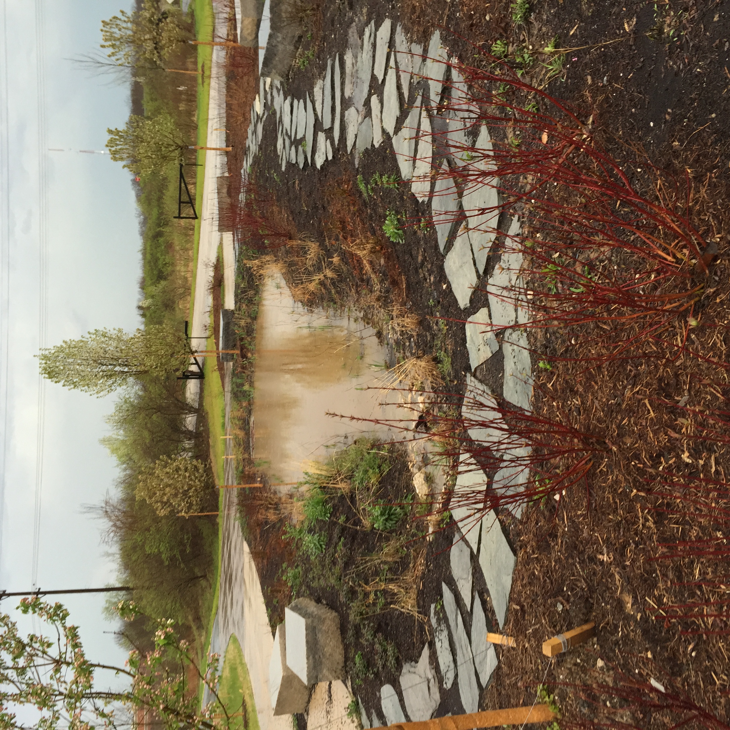
Whenever possible, we incorporate habitat restoration into our greenway projects. One way is by removing invasive plants—such as bush honeysuckle—and replacing them with native plants and trees to improve habitat and support pollinators. We also create rain gardens filled with native plants that not only attract bees and butterflies, but also help capture and filter storm water runoff. Here are 5 places to find native plants (and the pollinators they attract!) along greenways:
TEST TEST TEST
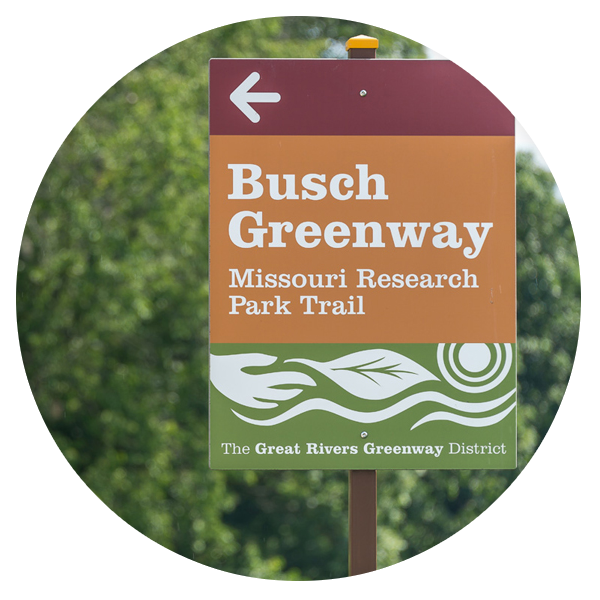
Tag: Busch Greenway
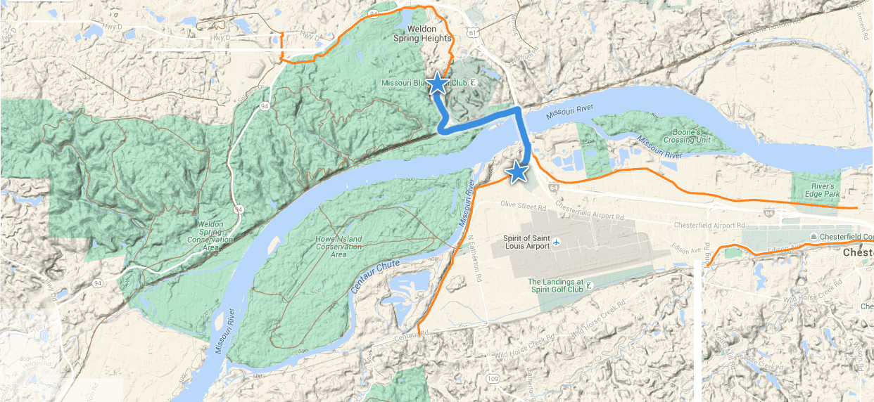
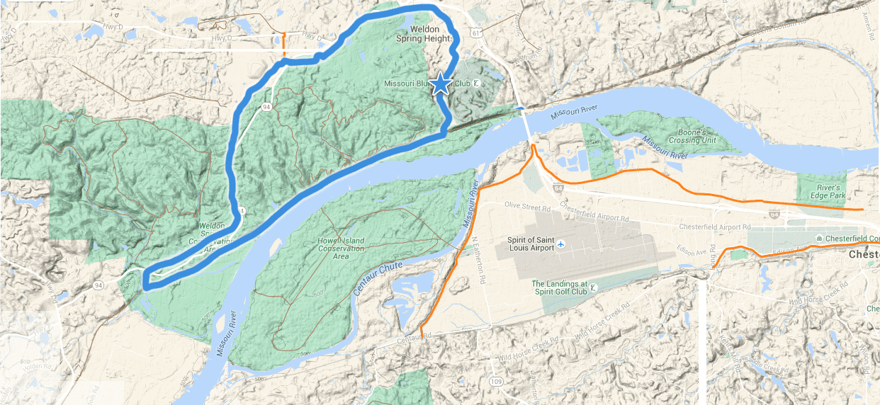
Greenway Getaway: Monarch Chesterfield Levee, Busch Greenway and KATY Trail
This greenway getaway is built around the walking and biking path on the Boone Bridge over the Missouri River. It offers stunning river views and connects two counties (St. Louis, St. Charles) and two greenways (Busch and Missouri Greenway: Monarch Chesterfield Levee) via the KATY Trail.
Whether you are just getting back on your bicycle, are a marathon runner, or simply looking for a new place to walk—this “Greenway Getaway” has something for everyone. Here are a few options depending on what you want to do!
5 MILE ROUTE

Starting at Busch Greenway Duckett Creek Trailhead in Missouri Research Park
This is a perfect walk, run or easy bike ride for people of all ages. It offers plenty of shade, great river views and there are no steep hills! Park at the Busch Greenway Duckett Creek Trailhead in the Missouri Research Park and walk .75 miles on the paved greenway down the bluff to the KATY Trail. Take a left, (east) and walk one mile to the new “cloverleaf” that takes you up to the pedestrian path across the Boone Bridge. At first glance, it looks a little steep, but the incline is very gradual. There are a couple of bump outs on the bridge where you can stop and enjoy the views of the Missouri River. Keep walking or riding across the bridge to the Missouri Greenway: Monarch Chesterfield Levee. The trip across the bridge from the cloverleaf to the Missouri Greenway is .75 miles. Stop at St. Louis Premium Outlets for a quick break. Turn around and head back across the river the same way for a total trip of 5 miles. (shorten the trip by turning around on the bridge.)

13 MILE ROUTE
From Missouri Greenway: Monarch Chesterfield Levee at St. Louis Premium Outlets
This trip offers gorgeous views of the River from atop the bridge and along the KATY Trail. St. Louis Premium Outlets welcomes you to park in the northwest corner of their parking lot near the levee. You can also use their restrooms during business hours. You will have to walk up a short gravel road to access the Missouri Greenway’s paved trail on the levee. The trip across the bridge to the KATY trail is .75 miles. Travel down the cloverleaf and take a right (west) on the KATY Trail for one mile to connect with the Busch Greenway. Once you are on the Busch Greenway, you’ll meander through a shady hardwood forest as you head up the bluff towards Missouri Research Park (.75 miles). As you travel through Weldon Spring Conservation Area, you will enjoy lake overlooks, abundant wildflowers, and the occasional deer or wild turkey. Be sure to stop and read the interpretive signage that explains the history of the area. Just past the Highway 94 underpass you will come to a rain garden in a “roundabout.” You can continue to Highway D where the paved trail ends.
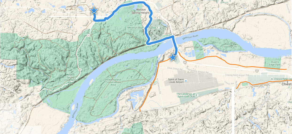
The mileage breakdown for the 13 mile trip is as follows:
.75 mile (paved) on Missouri Greenway: Monarch Chesterfield Levee across bridge from St. Louis Premium Outlets to KATY Trail
1 mile on KATY Trail (unpaved) to connect with Busch Greenway
.75 mile (paved, gentle incline) to Duckett Creek Parking Lot in Missouri Research Park (drinking fountain)
4 miles (paved) from Duckett Creek Parking Lot to Highway D
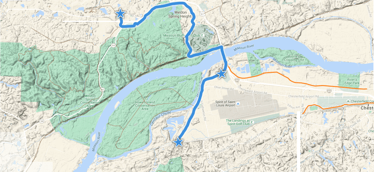
19 MILE ROUTE
You can add an additional six miles (three miles out and back) to the 13 mile route for a total of 19 miles. Stay on the paved Missouri Greenway: Monarch Chesterfield Levee and continue west, past the Premium Outlet Parking lot for three miles to where it currently ends at Centaur Road.
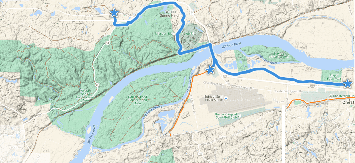
23 MILE ROUTE

Feeling ambitious? You can add another 10 miles (five miles out and back) to the 13 mile route for a total of 23 miles. Once you cross back over the Boone Bridge, take a right and go down the hill and under Highway 40 on the Missouri Greenway: Monarch Chesterfield Levee. Follow it for five miles to where it currently ends just past The District at Chesterfield (formerly Taubman Prestige Outlets). This is a flat, easy and sunny route.
OFF ROAD HALF-MARATHON ROUTE (13.1 MILES)
The Busch Greenway completes a 13.1 mile loop between the KATY and Hamburg Trails. This route is best for running or walking. You can do it on a bike, but you must have mountain bike tires as the route that follows the Hamburg trail is unpaved with a fairly rocky base. (The gravel is larger as compared to the KATY Trail.) Park at the Duckett Creek Trailhead parking lot. Run up the hill through Missouri Research Park and follow the greenway under highway 94 (4 miles). Just beyond the underpass, you will see a “roundabout” with a rain garden. Look for the sign that points to the Hamburg Trail and keep going (approx 3.75 miles) until it connects with the Katy Trail at mile marker 56.7. Go left (east) on the KATY for 4.6 miles to mile marker 52.1 and follow the paved Busch Greenway .75 miles back up the bluff to the Duckett Creek Trailhead where you began!

About the Busch Greenway
The Busch Greenway connects to the KATY Trail at mile marker 52.1. From there, it meanders 4.75 miles through Missouri Research Park and Weldon Spring Conservation to Busch Conservation Area at Highway D. Click here to learn more about the Busch Greenway and other sights along the way!
About the Missouri Greenway: Monarch Chesterfield Levee Trail
This greenway offers three segments which will eventually connect for a 17-mile loop. A 5.5 mile segment is now complete from Top Golf to Chesterfield Valley Athletic Complex and across the Boone Bridge. You can also follow the greenway in the other direction three miles to Centaur Road. A two mile segment has also been completed on the Monarch Levee from Long Road to Baxter Road. Click here to learn more about the Missouri Greenway: Monarch Chesterfield Levee Trail .
Busch Greenway Bridge Update
In August, a bridge in the Busch Greenway between the Katy Trail and Duckett Creek Trailhead sustained significant damage following a vehicular accident and was subsequently closed. We have been working diligently to assess the condition of the bridge and have determined the damage is fairly extensive. This bridge was never designed with vehicular traffic in mind, and the additional stresses and wear and tear took their toll on the structure.
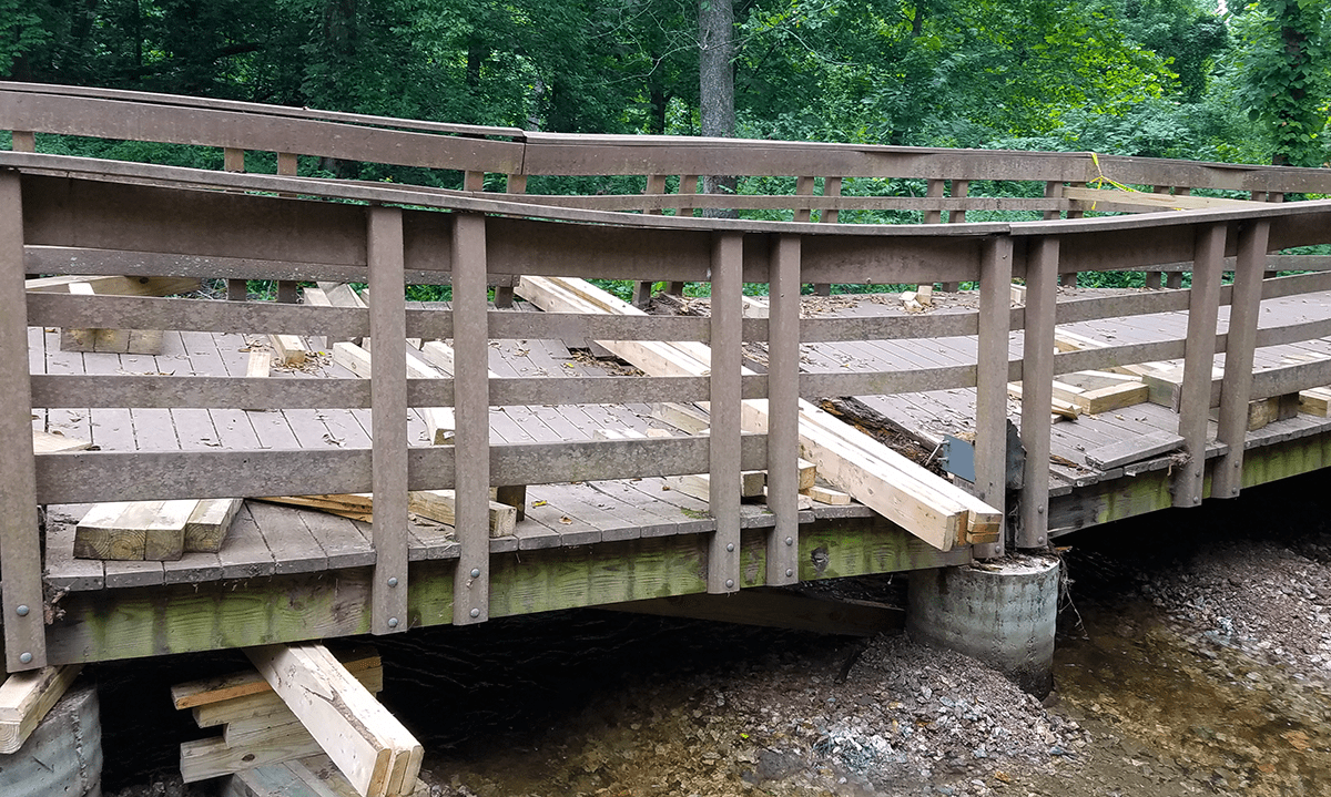
While it may appear to the casual observer as if the bridge can be fixed with a few boards and some light carpentry, its repair will require some degree of design and engineering. While this will ensure that the repaired bridge is safe and strong, it does add time to the process.
 As stewards of your tax dollars, and as required by state law, we must follow a specified procurement process to interview or hire engineering firms, designers or to bid construction. These selections must then be approved by our board of directors before any work can take place on the project. We are also required to follow a variety of permitting requirements and environmental processes. This particular project, due to its location over a wetland, presents several challenges on this front.
While all of these layers of approval and oversight add time to the process, they serve a very important purpose that we cannot disregard. They ensure that your tax dollars are being used wisely and that all construction is environmentally responsible.
All totaled, the process to fix the bridge will take a few months, and because of the coming colder weather, it will likely be spring before it can reopen. Until then, we need your help to ensure the continued safety of the site.
We have repeatedly put up fencing and signage to block access to the bridge, but people continue to rip them out and climb through. Please plan an alternate route for your outing. If you do go all the way up to the bridge, discourage your walking or bicycling companions from crossing it.
If you are concerned about any vandalism or other conditions, let us know by using our online contact form at: https://greatriversgreenway.org/about-us/greenway-feedback/
 There are still 4 miles of the Busch Greenway to explore and enjoy from Duckett Creek to the August A. Busch Conservation Area. You can connect to the KATY Trail from the Missouri Greenway: Monarch Chesterfield Levee via the new walking and biking path on the Boone Bridge. You can also connect to the KATY Trail via the Centennial Greenway: Katy to Heritage and the Boschert Greenway.
We know there are a lot of people who are disappointed about this closure, and want to assure you that we are too! This is a well-traveled greenway and an important connection—we are very sorry to see it temporarily shut down.
In the meantime, we’ll be out at the Duckett Creek Trailhead on Friday, October 21 from 11am-1pm to hold “Office Hours on the Greenways.” Stop by to pick up a map, have a snack and chat with our team about anything at all!
We hope to see you there, and we truly appreciate your help in keeping this area safe until the bridge can be restored to its previous condition.
Missouri Greenway: Monarch Chesterfield Levee Connection to Boone Bridge, KATY Trail and Busch Greenway is now open!
Ribbon cutting to celebrate new connection Saturday June 18th at 9am
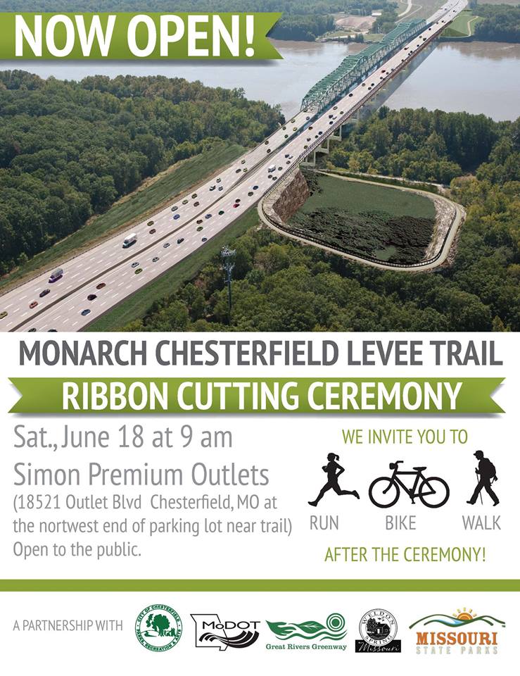 Join the City of Chesterfield and Missouri Department of Transportation as we celebrate the new Missouri Greenway: Monarch Chesterfield Levee connection to St. Charles County and the KATY Trail! The ribbon cutting is Saturday, June 18 at 9:00 am at the northwest end of the Simon Premium Outlet Center, adjacent to the greenway. All are welcome to join the fun. There will be brief remarks by number of community and elected officials, including Chesterfield Mayor Bob Nation and Weldon Spring Mayor Don Licklider.
Be sure to bring your bike or walking shoes so you can explore and enjoy this new connection after the ribbon cutting.
This Missouri Greenway: Monarch Chesterfield Levee offers three segments which will eventually connect for a 17-mile loop. Now that the bridge is open, there are 10.5 miles of trail built in this greenway for walking, running and riding a bike!
A 5.5-mile segment is now complete from the Hardee’s Ice Rink to the Chesterfield Valley Athletic Club and over the Missouri River to connect with the Katy Trail and the Busch Greenway. You can also follow the greenway in the other direction 3 miles to Centaur Road. A 2-mile segment is also complete atop the Monarch Levee from Long Road to Baxter Road. Click here to learn more about the Missouri Greenway.
Ribbon cutting celebration for new Busch Greenway extension in St. Charles County May 22
Residents of the region are now able to walk, bike or run all the way from the KATY Trail to the August A. Busch Conservation Area thanks to a new four-mile extension of the Busch Greenway. Great Rivers Greenway will be celebrating the recent completion of the paved trail with an official ribbon cutting event on May 22nd on the south campus of ABF International, located at #3 Missouri Research Park Drive, St. Charles, MO 63304, and adjacent to the new paved trail in Missouri Research Park. Area residents are invited to celebrate the new segment and explore the new connections made by the greenway.
The new Busch Greenway extension adds four miles to the existing 3/4-mile connector between the Katy Trail and Duckett Creek wastewater treatment facility in Missouri Research Park. The greenway now extends to the northern end of the business park, where it parallels Highway 94 and connects with the existing Hamburg Trail near the intersection of Highways 94 and D – creating almost five miles of greenway for people to explore and enjoy.
The project also completes a 13.1-mile loop linking the Busch Greenway, the Hamburg Trail, and KATY Trail, between mile markers 56.7 and 52.1, making it a great option for not only cyclists, but for those training for half-marathons as well. A new self-service bike repair station, donated by Momentum Cycles of St. Charles County, has been installed at the Missouri Research Park trailhead, adjacent to the Duckett Creek wastewater facility. The station comes equipped with an air pump for filling tires, along with eight commonly used tools for bicycle maintenance.
“People who are already enjoying Busch Greenway can see first-hand the many benefits of connecting our region’s green spaces and public lands,” says Susan Trautman, Executive Director of Great Rivers Greenway. “The four-mile extension seamlessly links together KATY Trail State Park, the Missouri Research Park and Missouri Department of Conservation lands. We are grateful for our partners who are equally committed to making Missouri’s beautiful green spaces even more accessible to all.”
The event is being held from 3-5 p.m., on May 22, with remarks from dignitaries and partners at 3:30 p.m. Attendees are welcome to take a free bike or golf cart tour of the greenway and enjoy kettle corn served by Ray Ray’s Kettle Corn, a local St. Charles business. The Missouri Department of Conservation, Missouri State Parks and Great Rivers Greenway will also be on hand to distribute maps and other information about area greenways, trails, parks and programs.