Master Plan
The master plan for the River des Peres Greenway calls for a continuous 11-mile corridor stretching between Forest Park and the Mississippi River. It will connect into the Deer Creek, Gravois, and Mississippi Greenways along with connections to the Bike St. Louis street routes at multiple locations.
Current Status
The River des Peres Greenway: Francis R. Slay Part to Shrewsbury/Lansdowne MetroLink to Carondelet and Lemay Parks travels through densely populated areas in south St. Louis, skirting the St. Louis city/county line, crossing several major intersections beginning at Francis R. Slay Park, then south to Shrewsbury/Lansdowne MetroLink station, to Chippewa, Gravois, and Morgan Ford. Approximately halfway between Lansdowne and the current endpoint of the greenway at Alabama Avenue, you can turn north on to the Christy Greenway; a neighborhood connector that takes you approximately 1 mile to Holly Hills Boulevard.
Similarly, the Carondelet Connector spurs north off the River des Peres Greenway at the intersection of Interstate 55 and Germania Avenue. You can walk or ride your bike and connect to all of the businesses at Loughborough Commons as well as Carondelet Park near the YMCA.
Projects In Progress
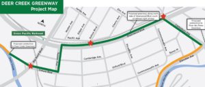
River des Peres Greenway to Mississippi Greenway
Construction to extend the Mississippi Greenway from its current endpoint on the River City Casino Property and connect with the River des Peres Greenway remains on hold, pending approval to complete greenway beneath railroad bridge.